3.440.500m²
Verified
Tuong Linh Industrial Park
Xã Thăng Bình, Thanh Hóa
- Đầy đủ
- Đa nghành nghề
CONTACT0392290588
 1 / 4
Xã Hoằng Sơn, Thanh Hóa
1. General Objectives & Legal Basis
Specificizing the Thanh Hoa Provincial Planning for the 2021–2030 period with a vision to 2045 approved by the Prime Minister in Decision No. 153/QD-TTg dated February 27, 2023; the Construction Planning of Hoang Hoa District, Thanh Hoa Province up to 2040 with a vision to 2070 approved by the Provincial People's Committee in Decision No. 1481/QD-UBND dated April 29, 2020; and the Master Construction Plan of Phu Quy Industrial Park, Hoang Hoa District, Thanh Hoa Province approved by the Provincial People's Committee in Decision No. 3087/QD-UBND dated August 31, 2023:
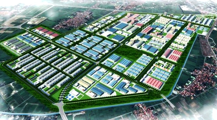
Build a modern industrial park with synchronized technical infrastructure and rational functional sub-zones to attract multi-industry investment projects.
Develop a high-tech industrial park which, alongside the emerging expressway network and other industrial parks, will serve as an advantageous location for attracting related industry sectors.
Establish a legal basis for identifying investment construction projects and detailing plans within the park. This aims to rapidly form a large-scale industrial park commensurate with the district’s potential and advantages, attracting high-tech projects to create competitive edges and breakthroughs for local socio-economic growth.
Create an industrial park that attracts investment, meets the needs of various economic sectors, and fosters socio-economic development for Hoang Hoa District and the province.
Increase the industrial labor ratio, contributing significantly to local labor restructuring.
3. Characteristics and Functions
A multi-industry industrial park prioritizing high technology, processing and manufacturing, mechanical engineering, automotive, pharmaceuticals, food processing, etc.
4. Workforce Scale
Projected workforce for the industrial park is approximately 36,000 to 58,500 people.
5. Land Use Structure and Planning Indicators
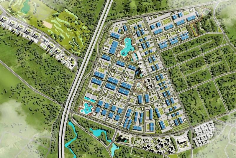
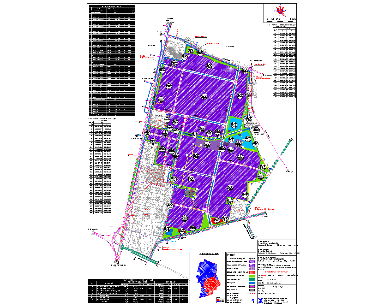
Total planned land area is approximately 540.0 ha, comprising:
a) Factory/Plant construction land: 393.31 ha (72.8%). Technical indicators: maximum building coverage 70%; maximum building height 5 stories; maximum floor area ratio (FAR) 3.5.
b) Administrative, public & service land: 3.18 ha (0.6%). Technical indicators: maximum building coverage 40%; maximum building height 5 stories; maximum FAR 2.0.
c) Technical infrastructure land: 11.80 ha (2.2%). Technical indicators: maximum building coverage 25%; maximum building height 2 stories; maximum FAR 0.5.
d) Greenery land: 54.67 ha (10.1%).
e) Water surface area: 21.02 ha (3.9%).
f) Transportation land: 56.02 ha (10.4%).
(Minimum building coverage for individual plots shall follow the approved master plan).
6. Spatial Organization
a) Factories and Plants: Flexible plot subdivision to accommodate various plant sizes. Areas along external transport corridors and main IP axes will prioritize large anchor enterprises.
b) Administrative, Public & Service Area: Includes administrative offices integrated with public/commercial services (e.g., showrooms) and cultural facilities for workers, strategically positioned near the main entrances.
c) Key Technical Infrastructure: Power sub-stations, wastewater treatment plants, fire protection facilities, etc., are centrally located near transport lines for seamless external/internal connectivity.
d) Greenery: Landscape and buffer green belts run along boundaries for environmental protection. Scattered green spaces are placed around water features to provide recreational/sports space for workers.
e) Transportation: Internal roads feature a grid layout connected to external transport networks, ensuring smooth access to each plot.
7. Technical Infrastructure Planning
7.1. Site Leveling
Elevation ranges from +2.0m to +3.0m (0.05% slope) with a perimeter dyke/embankment system built to +3.0m elevation.
Dyke system safety requirements: Maintain a 5m safety corridor from the embankment toe (usable for walkways/greenery); implement natural disaster mitigation/drainage measures; operate pumping stations continuously; perform regular facility maintenance.
7.2. Stormwater Drainage
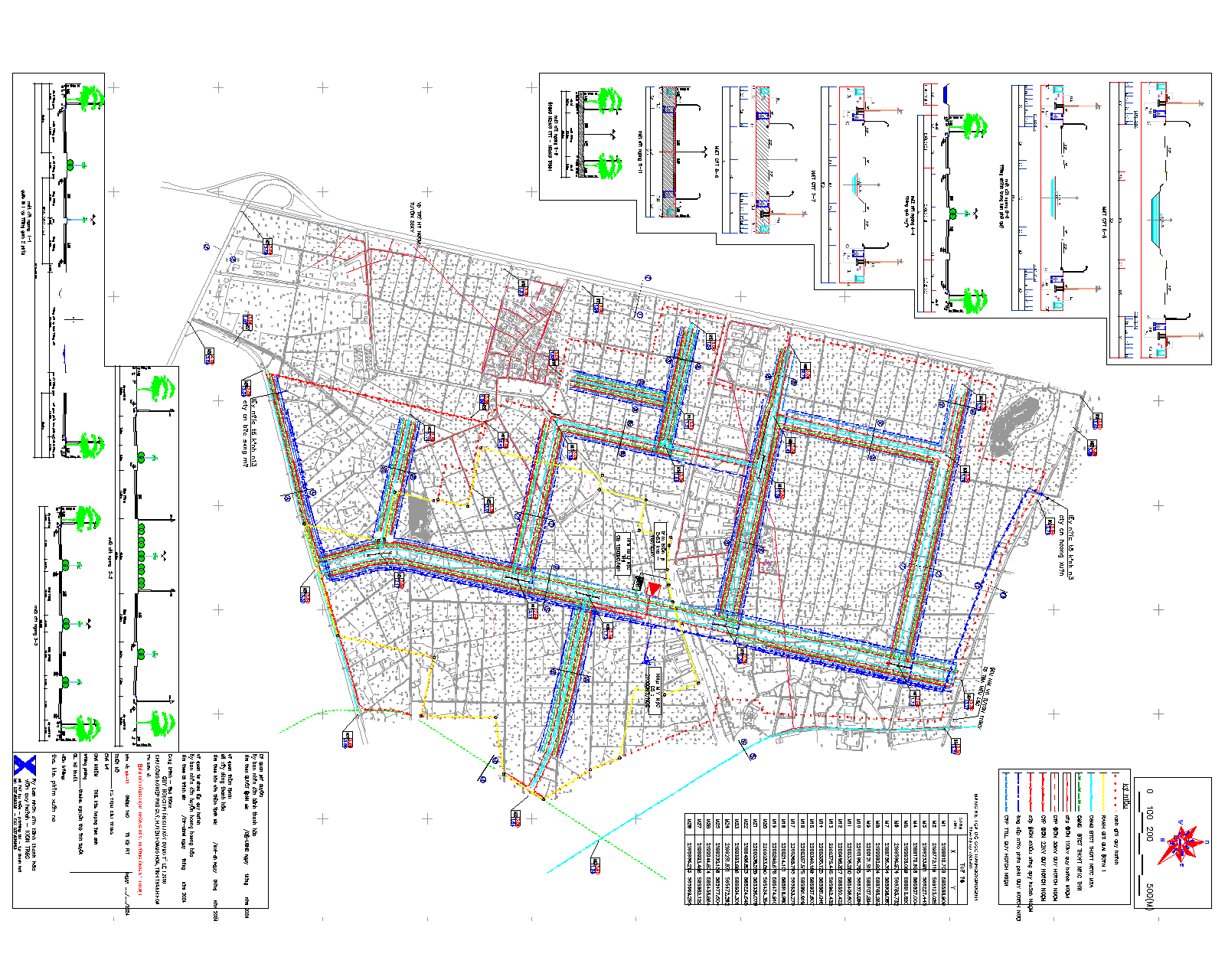
Separate stormwater and wastewater systems. Designed for gravity flow combined with a 30 m³/s forced pumping station discharging into the Quy Khe canal. Dredging of the Quy Khe canal and expansion of the Phu Dich culvert will be carried out.
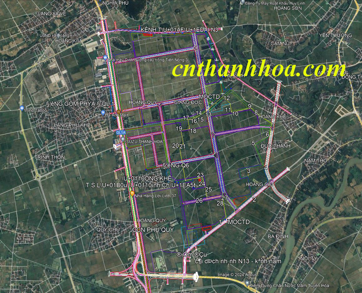
Divided into 4 main drainage catchments bounded by the central main drainage river, frontage roads (National Highway 1, Highway 1 Sub-project 2), main entrance axis P1, Kim Son Road, Quy Xuyen Road, and Hoang Trinh – Hoang Cat Road.
Rainwater is collected via underground pipes (D600–D1500 circular pipes and box culverts) under sidewalks.
Relocation of Canal N13 will restore/replace secondary culverts and canals with equal or larger cross-sections before the old channel is decommissioned.
7.3. Transport System
a) External Connections: Connects via eastern frontage road of National Highway 1 (10.5m road, 5m sidewalk); National Highway 1 Sub-project 2 (91m right-of-way); Kim Son Road (31m); Quy Xuyen Road (29m); Hoang Trinh – Hoang Cat Road (20.5m); and the connecting road from Eastern Ring Road No. 3 to But Son (56m).
b) Internal Traffic: Grid network anchored by main axis Road P1 (North-South, 3.2 km length, 66m right-of-way including 2x11.5m carriageway, 19m median, 2x10m sidewalks). Other internal roads have rights-of-way ranging from 35.0m to 54.0m.
7.4. Water Supply
Demand: 16,000 m³/day.
Source: Raw water drawn from branch N13 - South Canal passing through Phu Quy Industrial Cluster.
Construction of a new water treatment plant (21,000 m³/day capacity) and underground distribution network along sidewalks.
7.5. Power Supply
Demand: 123.4 MVA.
Source: Supplied from the new Hau Loc 220kV Substation (2x250MVA current, 3x250MVA vision to 2040) and a newly built 110kV Substation (3x63 MVA) within Phu Quy IP.
Network: 110kV high-voltage line, overhead 22kV grid on poles along roads, and underground 0.4kV low-voltage cables beneath sidewalks.
7.7. Wastewater Treatment & Environmental Sanitation
a) Wastewater: Processing demand of 8,900 m³/day. Construction of a 12,000 m³/day wastewater treatment plant and HDPE underground collection grid (min D300).
b) Solid Waste: Total generation of 118 tons/day. Domestic waste is collected and transferred to local sites (Hoang Thai: 1.5 ha, 25 t/day; Hoang Xuyen: 1.5 ha, 23 t/day). Industrial waste is packed and transferred to Hoang Xuan Treatment Site (5.0 ha, 500 t/day capacity, incineration/mixed tech).
7.8. Passive Telecommunications Infrastructure
Underground conduits/manholes along sidewalks; shared BTS towers (eco-friendly); public mailboxes/postal service points at administrative areas; 100% undergrounding of existing aerial cables.
8. Strategic Environmental Assessment (SEA)
8.1. Environmental Impacts:
Soil: Excavation/leveling changes soil mechanics/hydrology; industrial activities risk soil contamination.
Water: Direct impact from domestic/industrial wastewater and altered surface runoff patterns.
Air & Noise: Emissions and noise from industrial production and transportation.
Solid Waste: Large waste volumes create transport and management pressure.
Ecosystem: Land clearing/grading impacts local soil ecosystems.
Socio-Economic: Labor concentration brings public order, occupational safety, and disease control challenges.
8.2. Mitigation Measures:
Integrate green/water spaces; cluster factories by pollution levels; practice synchronized infrastructure standards; enforce dust suppression and proper compaction; treat 100% of wastewater to required discharge standards; control emissions at source; sort waste at source; minimize construction noise/vibrations; provide fair compensation, vocational training, and priority hiring for affected residents.
9. Housing, Resettlement & Cemetery Relocation Plans
Worker/Expert Housing: ~11 ha planned in East-South Phu Quy IP (adjacent to Quy Xuyen road), synchronized with Hoang Cat Commune planning.
Resettlement: ~148 households (Tan Duc village, Hoang Quy commune) allocated to a ~9 ha site east of National Highway 1.
Cemetery Relocation: Complete relocation of the existing cemetery in Tan Duc Village.
Xã Thăng Bình, Thanh Hóa
Xã Hà Long, Thanh Hóa
Xã Hoằng Giang, Thanh Hóa
Xã Thiệu Quang, Thanh Hóa